Water Resource Issues in the
Apalachicola–Chattahoochee–Flint Basin
Working Together for a Better Future
May 17-19, 2007
North Florida Research and Education Center
155 Research Road
Quincy, Florida
Map/Directions
(from MapQuest)
Home |
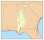
The Apalachicola–Chattahoochee–Flint river system is a major water resource shared by Alabama, Florida, and Georgia. The Chattahoochee River begins in the Blue Ridge Mountains of northern Georgia and flows southwesterly to the Alabama border, where it is shared by the two states as it flows south to Florida. It is joined there by the Flint river, which begins just south of Atlanta and flows south until it meets the Chattahoochee, forming Lake Seminole. The Apalachicola River leaves Lake Seminole and flows south to the Gulf of Mexico. Quincy, Florida is located near Lake Seminole. These waters are extremely important to the economies, recreation, and resources of the three states that share them. Better understanding of the resources and our impacts on them can guide us in their wise use and protection. The purpose of this Conference is to share information on water resource conservation issues and to encourage interaction among the Chapters. |
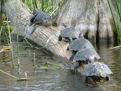 Sharing common resources
|
 |
Sponsored by the Alabama, Florida, and Georgia chapters of the Soil and Water Conservation Society |
Web site maintained by Kirk Iversen – kiversen@auburn.edu